


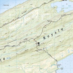
A rugged and isolated island on Lake Superior, Isle Royale offers unparalleled opportunities for hiking, backpacking, boating, paddling, and scuba diving in solitude, far from the sights and sounds of civilization. National Geographic's Trails Illustrated map of Isle Royale National Park delivers unmatched detail and valuable information to assist you in your exploration of this remote wilderness. Created in partnership with local land management agencies, this expertly researched map features key areas of interest including Passage Island, Rock Harbor, Windigo, and many shipwreck sites.
- Features
- Every Trails Illustrated map is printed on 'Backcountry Tough' waterproof, tear-resistant paper
- A full UTM grid is printed on the map to aid with GPS navigation
- Specifications
- Weight: ~ 3 oz
- Folded Dimensions: 4.25 x 9.25 in
- Unfolded Dimensions: 25.5 x 37.75 in
- Scale: 1:50,000
- Revised: 2019
- ISBN: 9781566953672